Tung Ping Chau

Shale - flooding on the island at the eastern tip of the territory ...

Tung Ping Chau is located on the north-eastern part of Tai Pang Wan (Mirs Bay). It is called Tung Ping on the map. In order not to be confused with Ping Chau which is close to the eastern part of Lantau Island, this eastern tip is then called Tung Ping Chau. (Tung means the east in Chinese).

From Ma Liu Shui (the University KCR Station), it takes you around 1.5 hours travelling to the island by the "Polly Ferry". On the way to Tung Ping Chau, you may find that it is just as "flat" as a huge floating bed on the sea. However, you may be amazed at its extraordinary beauty later!

GEOGRAPHY CLASS: Tung Ping Chau is well-known for its shale which is formed by hardened mud or clay under the sea. After ages, it divides into thin layers and the land is finally uplifted and the shale is now exposed on land above sea level. The shale on the island has its own well stratified pattern.
There are some local stores selling snacks and providing accommodation nearby.

For myself, I am fascinated by those noticeable small houses built by the shale on the island. There is an open area for BBQ, appreciating the stars and the moon. Imagine that there is no noise pollution of the TV programmes and you're now far away from the hustle and bustle... roaming slowly in the dark, appreciating the stars and the oceanic music and chatting with your sweet heart... BUT there is no need to count me in if you want to stay overnight at the beach...

To set off with the clockwise direction from the pier, the first stop is the Tin Hau Temple (the farthest one in the east of the territory). Walk along the coast for a short time, you now arrive at the "Keng Lau Shek". ("Keng" in Chinese means "shift duty"). I came here for the first time because of the sunrise. Yet, I finally found that I couldn't see it from the horizon. It is undoubtedly disappointing!

Anyway, "Keng Lau Shek" is still an interesting place. The two outstanding pieces of shale are in square shape. You might have thought there might be 2 guards stationing and they had been on duty without a stop if you watch them from a distance. That's why it is called "Keng Lau Shek". There is a wide open area nearby and most tourists like staying here for resting, playing and taking photos before they leave for the down-town.

Guess: Do you know what does it mean?

There are a couple of routes leading to other scenic spots. Yet, if you want to have a great walk on the island, you MUST pay attention to the tides. Making an all-round-island tour should be your choice.

If you want to get to the First Shale from "Keng Lau Shek", you may pass through "Lang Guo Shui" (in Chinese meaning - difficult to get through because of the water). Needless to say, you can't take this route unless it is low-tide. Or, you must take the trail to other places.

The "First Shale" and the "Second Shale" are the two most famous shale-cliff. Under the cliff, there is a large wave-cut platform. Those scattered and deserted pieces fall on the platform and form a marvellous view. Don't miss it.

Dangerous! Do have a careful walk through "Lang Guo Shui"(Keng Lau Shek is right behid it)

At the end of the route, the sea cave - "Hoi Law Dong" is not far away. Yet, you may wonder that you're now standing right up on the cliff. Don't worry! Turn around and walk for some metres, there is a path leading to the main trail. Walk ahead and you will find a very large piece of shale with its head right up on the top of the hill and its foot leading to the sea. It is just like a large dragon and it's so-called "Lung Lok Shui" (in Chinese, it means the Dragon (ie Lung) goes to the sea).

When you're now at the rocky beach and walk for some metres, you now reach the sea cave called "Hoi Law Dong". Inside the cave, the sitting-room-like cave tells you that its top is much wider than the lower part. At times, there's some water drops falling from the leak. You may feel like resting in a cave of stalactite.

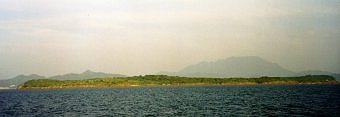
Walk along the coast and the geo - "Jam Ken Chau" is not far away. ("Jam" means cut and "Ken" means neck). It is originally called "Dun Tau Chau". ("Dun" means cut, "Tau" means head). Jam Ken Chau used to link with the tip of the island. However, it was separated and has finally formed the headland.

Why is it called "Jam Ken Chau"?
Please have a look at the place to which the gentleman is pointing. Can you imagine now?

Owing to its fantastic landscape, there are often light breezes and you surely feel refreshed. You can either walk along the coast or choose to walk back to the main trail leading to "Wong Ye Wan". Mind you that there are 
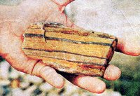
a lot of seashells and coral. Don't miss them and pick some to commemroate your wonderful walk!